|
|
 |
 |
||
 |
| Site Map | News | Organization |
| DOC | NOAA | NWS | NCEP Centers: | AWC | CPC | EMC | NCO | NHC | OPC | SPC | SWPC | WPC |
|
|
|
|
|
||
|
| Site Map | News | Organization |
| DOC | NOAA | NWS | NCEP Centers: | AWC | CPC | EMC | NCO | NHC | OPC | SPC | SWPC | WPC |
|
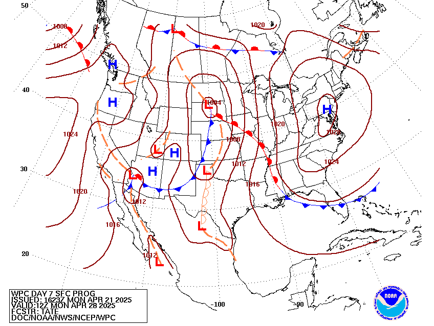
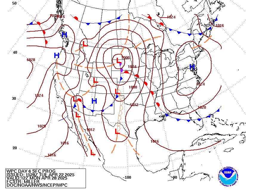
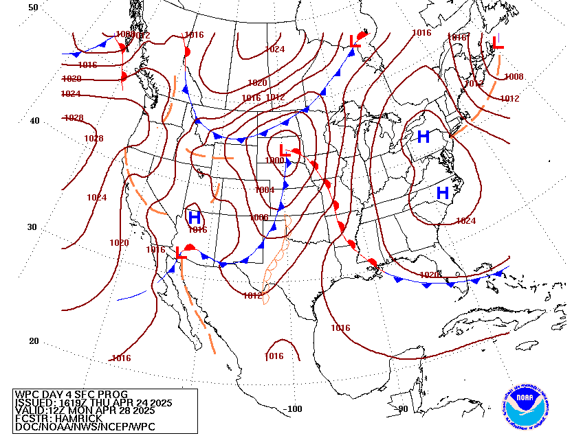
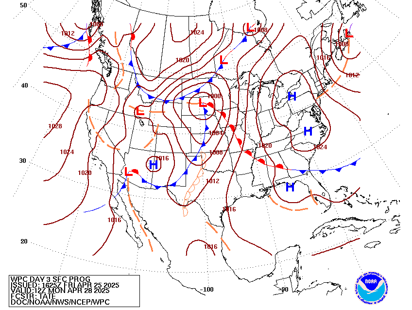
WPC Medium Range Archive
Medium Range Products Valid On:
04/28/2025
(Day 7 PMDEPD: Valid 04/24/2025 to 04/28/2025)
Extended Forecast Discussion
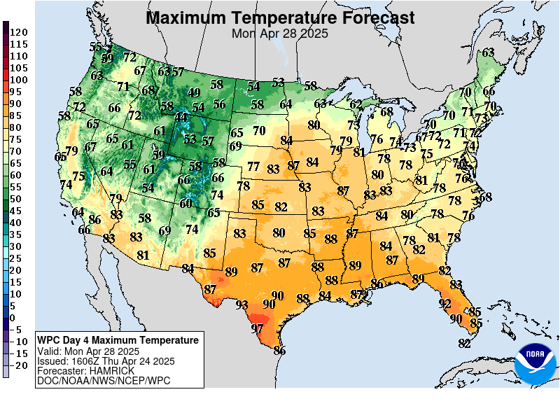
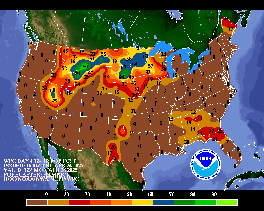
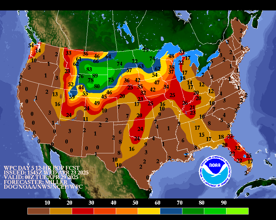
NWS Weather Prediction Center College Park MD 324 PM EDT Mon Apr 21 2025 Valid 12Z Thu Apr 24 2025 - 12Z Mon Apr 28 2025 ...Multi-day heavy rain threat for the South-Central CONUS... ...Overview... The medium range period begins Thursday with shortwaves moving through the central U.S. leading to rounds of thunderstorms that could cause heavy rain. Rain is likely to spread into the east- central and eastern U.S. with a low pressure/frontal system late week. Meanwhile upper troughing will move from the eastern Pacific into the western U.S. and promote modest precipitation in the Northwest, and moist inflow ahead of the trough will increase rain and thunderstorm chances in the central U.S. once again over the weekend. ...Guidance/Predictability Assessment... Model guidance remains in okay agreement on the large scale, but with differences on the smaller scale that could lead to sensible weather differences even early in the period. Shortwaves in the central to eastern U.S. late week lead to considerable QPF discrepancies. The 00Z CMC appeared to be an outlier as its shortwave and its associated surface low Friday-Saturday were farther west compared to the model consensus. Meanwhile the 06Z GFS tracked eastward rather than northeast with the low. The 00Z ECMWF was aligned well with the AI/ML models and this seemed most favorable. However, the 12Z CMC remained slow/west while the 12Z ECMWF jumped to be slower as well. Thus still plenty of uncertainty there. An upper trough moving through the eastern Pacific toward the West shows some spread even as the period begins regarding how much energy splits south versus stays north in the northeast Pacific. These yield timing and depth differences as the trough moves east. Fortunately incoming 12Z models look to have some convergence on the timing and track of this trough. The WPC forecast used a model (favoring the ECMWF) and ensemble mean blend early in the forecast period. But given the model discrepancies, increased the proportion of ensemble means to over half by Day 5 and almost the whole blend by Day 7, to smooth out the individual model differences. ...Weather/Hazards Highlights... Into later week, an ill-defined series of generally progressive upper features and surface based systems will continue to work over the lower 48 this week to focus local weather/convection. Likely multiple rounds of thunderstorms are forecast to focus in the south-central U.S. on Thursday as the pattern supports a moist and unstable flow for a favorable, at least local, flash flood setup. Recent and ongoing heavy rainfall over portions of these regions will make some areas particularly susceptible to additional rains. In coordination with the affected local forecast offices, will show a Slight Risk of excessive rainfall in the Day 4 (12Z Thursday to 12Z Friday) ERO from Kansas and northern Oklahoma into far western Missouri. Then on Friday, a low pressure system and its trailing front is likely to move across the Mississippi Valley toward the Great Lakes, spreading thunderstorm chances into those areas. Continue to indicate a Marginal Risk from Arkansas through portions of the Tennessee and Ohio Valleys for localized flooding with heavy rain, with minor adjustments from continuity. Some guidance suggests heavy rainfall farther northeast into the Upper Ohio Valley into the Lower Great Lakes region, so will continue to monitor. Meanwhile, despite some model guidance uncertainties in the details, upper trough amplification and digging in the eastern Pacific late this week moving into the West this weekend, along with surface system genesis and slow but steady system translation still offers increased light to moderate widespread rain chances and mountain snows. Renewed moisture streaming in east of the trough plus lingering boundaries in the area will allow for additional rounds of possibly heavy rain and thunderstorms in the Plains and Mississippi Valley by the weekend. Temperatures are likely to vary somewhat from day to day in the central and eastern U.S. as fronts progress through, but mostly be close to or above average. A handful of record or near record highs are possible in the Southeast and particularly over the west coast of Florida. Cooler than average temperatures, particularly for highs, are likely for the West Coast starting late week and moving into the Intermountain West by early next week underneath upper troughing. Tate/Schichtel Additional 3-7 Day Hazard information can be found on the WPC medium range hazards outlook chart at: http://www.wpc.ncep.noaa.gov/threats/threats.php WPC medium range 500mb heights, surface systems, weather grids, quantitative precipitation forecast (QPF), excessive rainfall outlook (ERO), winter weather outlook (WWO) probabilities, heat indices, and Key Messages can be accessed from: http://www.wpc.ncep.noaa.gov/medr/5dayfcst500_wbg.gif http://www.wpc.ncep.noaa.gov/medr/5dayfcst_wbg_conus.gif http://www.wpc.ncep.noaa.gov/5km_grids/5km_gridsbody.html http://www.wpc.ncep.noaa.gov/qpf/day4-7.shtml http://www.wpc.ncep.noaa.gov/#page=ero http://www.wpc.ncep.noaa.gov/wwd/pwpf_d47/pwpf_medr.php?day=4 http://www.wpc.ncep.noaa.gov/heat_index.shtml http://www.wpc.ncep.noaa.gov/#page=ovw
|
||||||||||||||||||||||||||||||||||||||||||||||||


