| WPC Met Watch |
|
|
Mesoscale Precipitation Discussion: #0193 |
|
(Issued at 237 AM EDT Tue Apr 29 2025
) |
|
| MPD Selection |
|
|
|
|
|

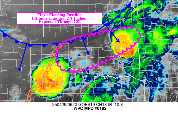
Mesoscale Precipitation Discussion 0193
NWS Weather Prediction Center College Park MD
237 AM EDT Tue Apr 29 2025

Areas affected...Eastern TX Panhandle into western/northern
OK/southeastern KS

Concerning...Heavy rainfall...Flash flooding possible

Valid 290635Z - 291230Z

Summary...Increasing coverage of thunderstorms over northern
OK/southern KS over the next 2-3 hours may pose an isolated flash
flood threat through 12Z for portion of the eastern TX Panhandle
into western/northern OK/southeastern KS. Rainfall rates of 1-2
in/hr and localized totals of 2-3 inches will be possible.

Discussion...Radar imagery at 0615Z showed a broken line of
thunderstorms along a cold front from eastern KS into northwestern
OK. The cold front was steadily advancing south into an unstable
(1000-2000 J/kg MLCAPE) but weakly to moderately capped
environment via 06Z SPC mesoanalysis data. Farther south,
southerly 850 mb winds were measured to be near 50 kt at the KFDR
VAD wind profile, roughly double the RAP analysis/short-term
forecast. While some veering of the low level wind is expected as
the cold front approaches from the north, the expectation is for
850 mb wind speeds to increase to the north over western OK over
the next 2-3 hours, helping transport higher 850-700 mb moisture
into the region which should help to reduce CIN. Further lift
forced by the cold front should also act to remove lingering
inhibition over the next 1-3 hours with cells initiating and
becoming elevated in the wake of the front. With mean steering
flow oriented parallel to the front (SW to NE), some instances of
training will be possible with 1-2 in/hr rainfall rates probable
within any axes of training.

Also of note, is a SW to NE oriented line of thunderstorms which
was located ahead of a dryline in western TX at 0615Z. This
cluster has been advancing northeast and continues to have cooling
cloud tops on infrared imagery, as it moves through an unstable
but also partially capped environment. It is unknown how long this
cluster will survive, but it it's able to to make it into
southwestern OK, it will overlap with a region that has seen 2 to
5+ inches of rain over the past few days. The cluster may have
influences on convection downstream over western OK given the
localized but enhanced low level moisture profile to be advected
toward western OK in conjunction with forcing on the leading edge
of the low level jet.

While there remains uncertainty in the exact forecast evolution
across the region, there appears to be sufficient evidence to
support at least a localized flash flood threat from the eastern
TX Panhandle into western/northern OK and southeastern KS.

Otto

ATTN...WFO...AMA...DDC...ICT...LUB...OUN...SGF...TSA...

ATTN...RFC...ABRFC...NWC...

LAT...LON   37569595 37569472 37169453 36289518 34559866
            34580057 36100076 36739967 37009847
Download in GIS format: Shapefile
| KML
Last Updated: 237 AM EDT Tue Apr 29 2025
|


